Adding directionality to stop signs in MapRoulette
The highway=stop tag is the OSM
representation
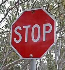
for a stop sign like this:

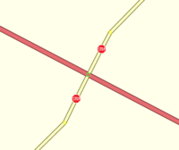
They are often placed on the intersection node of two ways, if there is a stop sign in all directions (a four-way stop). There are plenty of situations where the an intersection only has a stop sign in certain directions. In that case, the stop sign node is often placed on the way at the approximate location ahead of the intersection where the stop sign is placed:

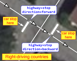
In those cases, to make the tag unambiguous, it is recommended to add a
direction tag to the node, to define in which direction the sign
faces, relative to the directionality of the OSM way, as defined by the
ordering of the nodes that make up the way: either forward or
backward as illustrated here:

However, the direction tags are often missing in OSM, making the tag
ambiguous. When we recently asked for ideas for new MapRoulette
Challenges on Twitter, fixing this was one of the suggestions!
How about adding "direction" to stop signs?
— Matthew Darwin (@matthewdarwin) December 1, 2020
It didn’t take long for the MapRoulette community to jump on this and create the Challenge for Matthew’s home province of Ontario, Canada. Thanks, Binnette!
Since you are from Ottawa, I made a #maproulette challenge for the whole Ontario. So you have 12k tasks to solve 😇https://t.co/MoYkb6V0gX pic.twitter.com/XH25CxbGlF
— Binnette (@BinnetteBin) December 2, 2020
These tasks should be fairly easy to solve, especially with the great instructions that go along with the Challenge. Can we fix all of them before the end of the year? Let’s get started!